Fire-Resistant
Landscaping for the
Home and Community
Al Murphy, Chief of Community Protection and Assistance, Bureau of Land Management
Guy Gifford, Landowner Assistance Forester, Washington Department of Natural Resources
Paula Dinius, Urban Horticulturist, Chelan County Extension, Washington State University
Introduction
Wildfires are inevitable, but the destruction of homes and the loss of lives is not. Whether or not a home burns in a wildland fire is primarily determined by conditions on private property.
Structure-fire disasters are not primarily caused by problems related to wildland fire control policies and procedures. Rather, they are caused by inappropriate landscaping and subpar Firewise construction standards. When this is understood and acted upon, home losses will be greatly reduced.
The primary responsibility and authority for preventing home destruction lies with homeowners rather than public land managers. This chapter deals with creating fire-resistant landscapes around homes and other structures.
Structure-fire disasters cannot be prevented without homeowners actively creating and maintaining a low ignition potential around their homes. The ignition potential is the possibility of an ember or flame to start a fire. Having a low ignition potential around a home effectively reduces the fire risk without necessarily controlling the wildfire, and this is without eliminating or reducing the wildfire exposure probability.
Purpose
The purpose of this chapter is to provide home gardeners with guidance and education about methods to landscape with fire-resistant plants. Fire-resistant plants placed in strategic areas around appropriately constructed homes or businesses, coupled with proper maintenance, can greatly reduce structure losses from wildland fires.
Fire Triangle
To understand how to create fire-resistant landscaping, a basic understanding of fire is necessary.
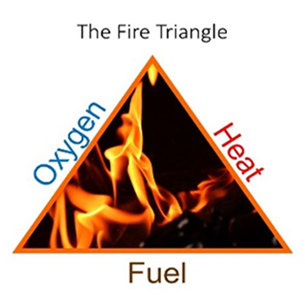
Heat, fuel, and oxygen are the three essential elements that must be present for a fire to start and burn (Figure 1). The fire triangle represents these three essential elements. If any of these elements of the triangle are missing, then a fire will not start or burn.
Of these three elements, the two we can affect are fuel and heat. We can design landscapes that contain minimal available fuel, and we can choose landscape materials and plants that will produce less heat and spread more slowly when burning.
Fire Behavior
The factors that affect how a fire will behave are fuel, weather, and topography. These three components are the variables that influence how intensely a fire will burn and determine how fast a fire will spread. With an extreme combination of fuels, weather, and topography, fires can burn extremely hot, generate large flames, and have the potential to spread very rapidly. The opposite is also true: with minimal fuels, favorable weather (cool and damp), and gentle topography (minimum slope or flat ground), fires will burn with low intensity (small flames) and at a slow rate of spread.
Human ability to modify weather on a large scale is extremely limited; the same is true for topography. The temperature, wind, and relative humidity are three components of the weather that have a strong influence on fire behavior. High temperatures, strong winds, and low relative humidity can create extreme fire behavior (large flames and a quick rate of spread). In many parts of the Pacific Northwest, summer weather often brings high temperatures, strong winds, and low relative humidity.
Topography is influenced by the geology of the area. Mountains, river drainages, rocky slopes, and vast plains dominate the topography of the Pacific Northwest. The three key factors of topography that affect fire behavior are slope (steep or flat), aspect (the direction the land faces), and special features such as draws (tight, valley-like features) and saddles (low point along a ridgeline). These three factors of topography affect fire behavior by influencing the heat transfer from burning material to adjacent fuels.
Of the three components of fire behavior—fuels, weather, and topography—fuels are the one component that can be modified.
Common Fuels Around a Home or Structure
Fuel is live or dead organic material that burns. Fuels exist in a variety of sizes, volumes, arrangements, and moisture contents. These fuel attributes combine to determine if a fire will start and how it will burn. Some common fuels around a structure are grasses, shrubs, trees, milled lumber, roofs.
Fuels can also be classified by their location relative to the surface of the ground. These fuel classifications are:
- Ground fuels—All combustible materials below the surface litter, including duff, tree or shrub roots, rotted wood, peat, and sawdust, that normally support a glowing combustion without flame.
- Surface fuels—Fuels lying on or near the surface of the ground, including leaf and needle litter, dead branch material, downed logs, bark, tree cones, and low-stature living plants.
- Ladder fuels—Fuels which provide vertical continuity between strata, thereby allowing fire to carry from surface fuels into the crowns of trees or shrubs with relative ease. They help initiate and assure the continuation of a crown fire.
- Aerial fuels—Standing and supported live and dead combustibles not in direct contact with the ground and consisting mainly of foliage, twigs, branches, stems, cones, bark, and vines.
Fuels, as was mentioned, can be modified in a variety of ways. Changing the composition of fuels or altering where the fuels are physically located are actions that can be taken to modify the fuel continuity around a structure. Collectively, fuels, weather, and topography are the key components that determine how intensely (hot) a fire will burn and how fast it will spread.
Heat (Energy) Transfer
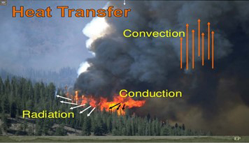
There are three methods of energy transfer (Figure 2). Heat is a form of energy, so, in this context, the terms can be used interchangeably. The three methods of energy transfer are: radiation, convection, and conduction.
Radiant energy is the term for electromagnetic waves moving through the air to heat an object. Radiation is easily explained through a campfire example. Suppose a campfire is burning at an intensity that allows people to sit relatively close to the fire. Then, suppose one of these people adds more firewood. Everyone around the campfire now must back up to get away from the now very hot fire. The heat they are experiencing is radiant energy. One does not have to back up too far to find a comfortable distance, because the radiant energy (heat) decreases rapidly the farther one moves from the campfire. In a wildfire situation, radiant energy heats adjacent fuels, often to the point of ignition. Around a home, an efficient method for dealing with potential radiant heat from a wildfire is to increase distance between burnable objects. This is because radiant energy decreases rapidly as the distance between objects increases.
Convection is the term describing heat transfer by mass motion of air. When heated air moves away from the source of heat, it carries heat (energy) with it. Convection above a hot surface, such as that generated by a fire, occurs because hot air expands, becomes less dense, and rises.
Finally, conduction is the movement of energy (heat) through a substance by the movement of molecules. Heat flows from the warmer object to the cooler object until they are both at the same temperature. An example of conduction is a metal pan on a burner. The metal handle of the pan gets hot even though it is not over the open flame.
Factors of Fire Spread and Intensity
How fast a fire spreads and how intensely it burns are functions of several factors. Those factors are:
- Fuel moisture (how wet or dry a fuel is).
- Fuel size (large, medium, or small).
- Fuel volume (how much fuel is present and available).
- Fuel bed height (how high the fuels are).
- Fuel arrangement (how compact or loose the fuel is).
- Slope (the angle of the topography, whether flat or steep).
- Weather (the combination of temperature, wind, and relative humidity).
Depending on the fuel, weather, and topography, there are several forms of fire spread:
- Creeping or smoldering—A fire that slowly burns in deep accumulations of dead vegetation, such as peat or humus.
- Surface—A fire that burns litter and duff found on the soil surface.
- Torching—A fire that runs up a tree or trees from the bottom upwards.
- Crowning or aerial—A fire that advances across the tops of trees or shrubs more or less independent of a surface fire. Crown fires are sometimes classed as “running” or “dependent” to distinguish the degree of independence from the surface fire.
- Spotting—A new fire starting from a spark or ember carried by the wind to a new area away from the main fire.
The intensity and spread rate generally increase from creeping/smoldering, to surface, to torching, to crowning/aerial fires, respectively. For that reason, torching, crowning/aerial, and spotting fire pose the greatest threats to homes and other structures. This is not to say that creeping/smoldering and surface fire do not pose a threat to homes, the threat is just at a lower level.
Embers (Firebrands or Sparks)
The three primary ways that wildfires threaten homes are (1) direct contact by flames, (2) radiated heat, and (3) embers. Researchers have found that 70 to 90% of the homes that are lost in wildland fires are due to burning embers. Embers cause more structures to burn than any other heat source. When fire conditions are right, embers can be lofted high into the air and transported more than a mile from the main fire. Embers can also be carried by wind and fire whirls. If embers land in easily ignitable materials, such as dried grass, fallen leaves, wood shake roofs, or leaf- and needle-filled gutters, a new fire can easily start. Homeowners can take action to reduce the ignition potential on and immediately adjacent to the home to combat incoming embers.
Fire Statistics
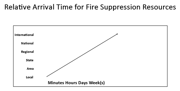
Fire agencies are highly effective at suppressing wildland fires. Across the United States, between 96% and 98% of all wildland fires are suppressed to less than one acre. However, about 3% of wildland fires account for approximately 97% of the acreage burned. These statistics point out a potential problem in the allocation of fire suppression resources. During “normal” fire seasons and conditions, most agencies can deal with their suppression workload with local suppression resources. However, during extreme conditions or events, local agencies are overwhelmed and soon run out of suppression resources. During these times, other cooperating agencies share fire suppression resources. When conditions are extreme within a relatively small area or jurisdiction, wildfires are generally dealt with in an effective manner in a short period of time, but when conditions become extreme and suppression resources are limited, the fire is normally not isolated to just a small geographic area. Suppression resources can become scarce over a large geographic area, such as several states or an entire portion of the country. It is during these times of limited suppression resources that the greatest losses occur. Figure 3 demonstrates an approximation of the time that is necessary for obtaining additional suppression resources from cooperators. The farther the suppression resources have to travel, the longer the arrival time.
Wildland Urban Interface
The Wildland Urban Interface (WUI) is the area where wildland fuels overlap with urban development. The WUI, also called the interface, is the most challenging area due to the potential for loss of life and property. The WUI can be an area where there is a definable line between wildland and a development or it may be an area where homes and other development structures are intermingled with wildlands. In both cases, when a fire is burning or threatening a WUI area, the situation is very serious and has a high potential for loss of life or property.
Research Findings
There have been several research studies conducted to investigate structure survival versus loss in wildland fire situations. Jack Cohen, US Forest Service, conducted a research project to determine the survivability of wooden structures during high-intensity crown fires. Among other things, he found that wooden structures will not sustain combustion from the radiation of a high-intensity crown fire on flat ground or slopes less than 20% at a distance of 100 feet or more. This research offers valuable information for protecting homes and other structures from wildland fires; namely, that structures can be saved from burning when fuels around them are reduced or fuel composition is changed to become more fire-resistant.
Other research found that 95% of all homes with nonflammable roofs and a 30–50 foot buffer survived a blaze. In another study, 86% of homes with 30-foot buffers and nonflammable roofs survived a fire. These are important findings and indicate that survivability of a home does not necessarily come from a suppression response but instead through preplanned and well-executed vegetation (i.e., fuel) management.
Responsibility in the Wildland Urban Interface
Who generally is responsible for the land and vegetation immediately surrounding a home? Each homeowner has the authority and responsibility to manage the vegetation on their property. The vegetation and construction materials are the responsibility of the homeowner. Wildland fire agencies and local fire departments generally do not have the authority to manage vegetation on private property. They are primarily tasked with education and code enforcement as well as fire suppression. Though homeowners are responsible for the vegetation on their property, there are many agencies that help homeowners manage their vegetation. Agencies at the federal, state, county, and city level in many areas of Washington can provide homeowner assistance. The level of assistance requested by homeowners as well as the level of assistance available varies widely across jurisdictions. The Washington State Department of Natural Resources (opens in new window) is an agency that can provide information to homeowners seeking assistance in managing the vegetation on their property. Their main office can be reached by phone at 360-902-1300.
Firewise Concepts
The Firewise concept is aimed at reducing losses from wildland fires. To reduce loss, four key steps can be taken:
- Reduce fuels around the home.
- Construct the home with flame-resistant materials.
- Provide safe access for fire suppression resources.
- Be prepared with an emergency plan.
Washington State has a unique geological and geographical situation, having the moist/mesic western side and the dry eastern side. The ecological conditions on the western side are different from the eastern side. Historically, the natural fire regimes were very different on either side of the mountains. In recent times, with an increase of the human population, people-caused ignitions have become a primary source, and the differences between westside and eastside fire occurrence are greatly reduced. With the construction of thousands of homes in the forested environment of western Washington, the number of homes lost to wildland fire has increased dramatically. Westside residents often assume the WUI issue is an eastside problem. This is flawed thinking; the risk and the potential losses in the WUI are high on both sides of the Cascades. Recent years have seen a significant increase in homes being threatened by wildfire in western Washington.
Fire-Resistant Home Construction
A home’s design, location, construction materials, and access all influence its survivability during a wildland fire. The most exposed portion of the home is the roof. Fire-resistant roofing greatly improves the likelihood of the structure surviving a wildland fire. The use of fire-resistant building materials, such as cement board siding and dual-pane windows, helps reduce the probability of a wildfire home ignition. Additional home measures, such as boxed-in eaves and metal screening (1/8 inch or less) covering vents, further reduces the probability of ignition. It is important to make sure decks and fencing are in good repair and free of clutter and debris. Remember, “if it is attached to the house, it is part of the house!” Consider the use of metal gates and other nonflammable materials to separate fences and decks from the home and other structures. There are also fire-resistant decking materials available to reduce the ignition potential.
In addition to the materials that the home is constructed with, the materials that surround the home also must be considered for their flammability. Lawn furniture, decorations, welcome mats, and other flammable items may also pose an increased risk to the home. These items can be removed and stored in a safe area during threatening times. See National Fire Protection Association Firewise USA (opens in new window) and the Insurance Institute for Business & Home Safety (IBHS) (opens in new window) for additional information about building materials and construction standards.
Home Ignition Zone
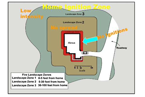
The Home Ignition Zone (HIZ) concept was developed by Jack Cohen based on several research projects that he conducted or was involved with.
The Home Ignition Zone begins at the home or other structure on the property and extends out as far as 100 to 200 feet, depending on the characteristics of adjacent lands. Keeping the Home Ignition Zone lean, clean, and green reduces ignition risk, fire-spread potential, and fire intensity. Maintain well-spaced plants (lean), remove all dead vegetation (clean), and keep the vegetation well-watered (green) during the fire season.
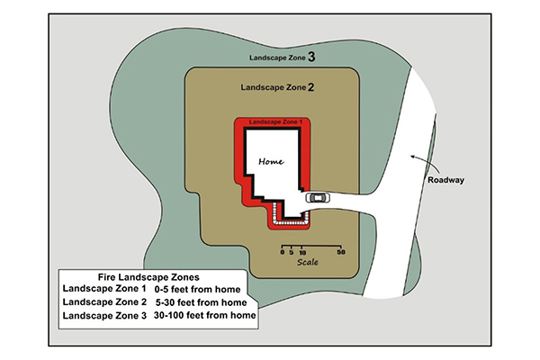
Within the Home Ignition Zone, a fire-resistant landscape can be created by reducing flammable fuels. A method to accomplish this is to establish landscape zones that start at the home and move progressively outward (Figure 4). These Landscape Zones (LZ) within the Home Ignition Zone can guide the selection of fire-resistant vegetation in fire-prone environments.
Landscape Zones
Landscape Zone 1 (LZ1) is the area from zero to five (0–5) feet out from the home or structure that is constructed with one-hour, flame-resistant siding. For structures constructed with non-flame-resistant siding, the area is zero to ten (0–10) feet from a structure. Nothing flammable should be planted or placed in this zone. The objective in this zone is to have no ignitions. Within this zone, low-flammable plants can be planted if they are properly cared for and maintained. Rock mulches are a good addition for maintaining soil moisture and reducing weed growth.
The desired categories of plants in LZ1 are groundcovers, vines, sod grasses, bulbs, annual and perennial herbaceous plants, and nonflammable, inorganic mulches.
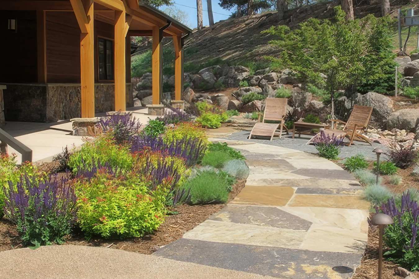
Landscape Zone 2 (LZ2) is the area five to thirty (5–30) feet from the house or structures. The objective in this zone is to prevent any fire spread if an ignition were to start. To create a fire-resistant LZ2, maintain a well-kept lawn or other suitable landscape in this area. Use raised beds, rock gardens, stone walkways, walls, water features, and patios to create visual interest and serve as features to slow or prevent fire spread (known as fuel breaks).
The desired categories of plants in LZ2 are groundcovers, turfgrass, vines, sod grasses, bulbs, annual and perennial herbaceous plants, broadleaf evergreen and deciduous shrubs, small- and medium-sized deciduous trees, and select non-turf (ornamental) grasses.
Landscape Zone 3 (LZ3) is the area 30 to 100 (up to 200) feet from the house. The objective in this zone is to reduce fire intensity. If an ignition starts in this zone, it may spread, but it would burn at a low intensity, thus reducing the heat transfer to other vegetation. To have a fire-resistant LZ3, remove yard debris and thin vegetation 30 feet away from the house or other structures. Properly designed driveways within the LZ3 can provide a fuel break as well as safe ingress and egress for fire suppression resources. On slopes greater than 20%, one should extend the thinning of vegetation to 200 feet or more on the downhill side of the home or structure. Trees, shrubs, and ground covers should be selected based on their size at maturity, not the size at the time of planting. Low and moderately flammable plants are acceptable in this location. Density of plant material also should be minimized. Brush and weeds should be mowed at least annually. Terracing of steep slopes will help slow wildfire spread, but this depends on wind speed and fuel availability. Trees in LZ3 should have a minimum of 5 to 20 feet of space between the widest part of tree crowns to prevent the spread of fire through the crowns.
Another technique in LZ3 is to reduce the chances of wildfire from climbing into the crowns of the trees or large shrubs. Removing any ladder fuels that will carry fire into the crowns can be accomplished several ways:
- Prune trees 10 feet high but maintain approximately 50% of the tree in live branches; for example, prune a 12-foot-tall tree 6 feet high. This is for the health of the tree.
- Remove shrubs from under trees that could carry fire into the crowns of the trees.
Desired categories of plants in LZ3 include groundcovers, vines, turfgrass, annual and perennial herbaceous plants, broadleaf evergreens, deciduous shrubs, deciduous trees, and non-turf (ornamental) grasses.
The following diagram (Figure 5) of the Home Ignition Zone depicts the Landscape Zones and the fire behavior objective for those zones.
Fire-Resistant Vegetation
Some landscape plants are described and marketed as fire-resistant (see Table 1 for more information). It is important to remember, given certain conditions, that all plants can burn regardless of how they are classified. In general, select plants that are low growing, open structured, and less resinous (oily or waxy). Plant maintenance and placement are equally important as the species of plants selected for the site. Maintenance and landscape management (e.g., pruning, watering, and cleanup) have an impact on whether a plant ignites. When choosing plants for a fire-resistant landscape, select plants with the following fire-resistant characteristics:
- Low growing.
- Herbaceous plant parts.
- Water-like sap.
- Broad leaves.
- Tight bark.
- High moisture content in leaves/succulent parts.
- Little or no seasonal accumulation of dead vegetation.
- Open branching habits (they provide less fuel for fires).
- Fewer total branches and leaves (again, less fuel for fires).
- Slow growing, so less pruning is required (to keep open structure as noted above).
- Non-resinous material on the plant (i.e., stems, leaves, or needles that are not resinous, oily, or waxy). Junipers, pines, spruces, and firs are resinous and highly flammable.
| Plant category | Fire resistance level | Relative flammability |
|---|---|---|
| Conifers | Low resistance | 🔥🔥🔥🔥🔥 Very high flammability (least fire resistant) |
| Grasses | Low resistance | 🔥🔥🔥🔥🔥 Very high flammability (least fire resistant) |
| Shrubs | Low–Moderate resistance | 🔥🔥🔥🔥 High flammability |
| Deciduous Trees | Moderate resistance | 🔥🔥🔥 Moderate flammability |
| Perennials | Moderate resistance | 🔥🔥🔥 Moderate flammability |
| Annuals | Moderate–High resistance | 🔥🔥 Low flammability |
| Vines | High resistance | 🔥🔥 Low flammability |
| Ground Covers | High resistance | 🔥 Very low flammability (most fire resistant) |
| Succulents | Very high resistance | 🔥 Very low flammability (most fire resistant) |
Unfavorable Plant Characteristics
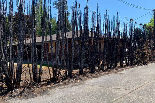
Arborvitae, the common name given to at least eight different species and cultivars of the genus Thuja, are one of the most fire-prone and least fire-resistant shrubs (Figure 7) that can be planted in the Wildland Urban Interface (WUI). Arborvitae is not a recommended plant. There are several species of juniper that are also not recommended. Both arborvitae and juniper have a thin covering of green vegetation over a dense mat of dead, very flammable material underneath the green covering.
Table 2 has a short list of some of the plants that are not recommended for use in fire-prone environments. The plants in this category have some common characteristics:
- High surface area to volume ratio; this means the plant has fine-textured parts.
- Low moisture content.
- High percentage of dead fuel matter or debris.
| Trees | Shrubs | Grasses |
|---|---|---|
| Pine | Bitterbrush | Pampas grass |
| Fir | Sagebrush | Cheat grass |
| Larch | Mugo pine | ‘Karl Foerster’ grass |
| Spruce | Arborvitae | Not applicable |
| Douglas-fir | Juniper | Not applicable |
| Yew | Yew | Not applicable |
| Arborvitae | Not applicable | Not applicable |
| Hemlock | Not applicable | Not applicable |
| Cedar | Not applicable | Not applicable |
| Juniper | Not applicable | Not applicable |
Source: Al Murphy, Bureau of Land Management.
Many people enjoy conifers, but most conifers do not possess fire-resistant attributes. However, some conifers are very fire resilient; they have adapted to survive in fire-prone environments. Homeowners can employ maintenance techniques to reduce the fire hazard of conifers. Some of the maintenance techniques may include thinning, pruning, removing dead needles in the tree, raking, providing plenty of distance from structures, keeping the area around the tree clean, and properly disposing of vegetative debris. It is important to keep in mind that these trees continue to pose a fire hazard.
Favorable vs. Unfavorable
Fire-Resistant Plant Attributes
| Height: | short | vs. | tall |
| Width: | spread-out | vs. | thick or dense |
| Stem composition: | herbaceous | vs. | woody |
| Leaf structure: | broad leaves | vs. | needles |
| Leaf retention: | deciduous | vs. | evergreen |
| Plant tissue fluids: | high-moisture content | vs. | low-moisture content |
| Vascular system fluids: | watery | vs. | thick or sticky sap |
| Bark characteristics: | tight | vs. | loose bark (refers to bark texture) |
Maintenance
Maintenance is essential to a fire-resistant landscape. Plants listed as fire-resistant, if allowed to grow unchecked and are poorly maintained, can become fire hazards. Table 3 is intended to provide an approximation of the frequency of maintenance necessary to maintain a fire-resistant landscape in the Home Ignition Zone. All of these practices need to be done at least annually, some more frequently. Each home and geographic region has differing needs, timings, and frequencies of maintenance. The objective is to practice “lean, clean, and green” at least 30 feet around structures during the fire season to reduce fire spread and intensity.
Table 3. Frequency and maintenance practices for fire-resistant landscapes.| Maintenance Practice | Season | Not applicable | Not applicable | Not applicable |
|---|---|---|---|---|
| Not applicable | Spring | Summer | Fall | Winter |
| Wash dead debris out of plants | X | X | Not applicable | Not applicable |
| Prune to remove ladder fuels | X | O | X | O |
| Thinning | O | X | X | X |
| Raking | X | X | X | Not applicable |
| Weeding | X | X | X | Not applicable |
| Mow/Weed Trimming | X | X | Not applicable | Not applicable |
| Use only inorganic mulch close to structures | X | Not applicable | Not applicable | X |
| Water | X | X | X | Not applicable |
| Clean roofs and gutters | X | X | Not applicable | X |
| Clean up and properly dispose of yard waste | X | X | X | Not applicable |
| Remove dead fuels | X | X | X | X |
| Separate shrubs horizontally so they are no closer than twice their height | X | O | X | X |
| Separate plants vertically so the space between the top of a shrub and the lower branches of a tree are at least three times the height of the shrub (removing ladder fuels) | X | X | X | O |
Source: Al Murphy, Bureau of Land Management.
Note: “X” indicates primary season to accomplish maintenance tasks. “O” indicates optional time to accomplish maintenance tasks.
1 Take caution when pruning conifers such as pine, spruce, and Douglas-fir from April to October when the adult pitch moth is laying eggs.
They are attracted to fresh pruning wounds, and the larvae can cause significant damage to the tree.
Table 2 outlines recommended maintenance practices for fire-resistant landscapes and indicates the seasons in which each task should be performed. An “X” denotes the primary season for completing a task, while an “O” indicates an optional time.
Several routine maintenance activities should be performed primarily in spring, summer, and fall. These include washing dead debris out of plants, raking, weeding, mowing or weed trimming, watering, cleaning roofs and gutters, cleaning up and properly disposing of yard waste, and removing dead fuels. These tasks help reduce the buildup of flammable material throughout the fire season.
Pruning to remove ladder fuels—vegetation that can carry fire from the ground into tree canopies—is primarily recommended in spring and fall, with optional timing in summer and winter. Thinning vegetation is optional in spring but is primarily recommended in summer, fall, and winter. Similarly, maintaining horizontal spacing between shrubs (so they are no closer than twice their height) is primarily recommended in spring, fall, and winter, with summer as an optional time. Vertical spacing between plants—ensuring the distance between shrubs and tree branches is at least three times the shrub height—is recommended primarily in spring, summer, and fall, with winter as an optional time.
Some practices are more season-specific. Using only inorganic mulch close to structures is recommended in spring and winter. Cleaning roofs and gutters is emphasized in spring, summer, and winter. Removing dead fuels is important year-round, including winter.
The table also includes a note that “X” indicates the main season for completing a task and “O” indicates an acceptable but less critical time. An additional caution advises avoiding pruning of conifers such as pine, spruce, and Douglas-fir from April through October, when pitch moths are active and attracted to fresh pruning wounds, potentially causing damage to trees.
Overall, the table emphasizes consistent, seasonal maintenance to reduce fire risk by managing vegetation, removing debris, and maintaining proper plant spacing.
Further Reading
2016 Chelan County Noxious Weed List (link to PDF document). 2016.
Barkley, Y., C. Schnepf, and J. Cohen. 2005. Protecting and Landscaping Homes in the Wildland/Urban Interface (link to PDF document). Idaho Forest, Wildlife and Range Experiment Station Bulletin. University of Idaho Extension. A Firewise document that discusses a broad spectrum of topics, including a recommended plant list, preventing loss of home, and evacuation tips.
Bennet, M., and C. Nichols. 2020. The Home Ignition Zone: Protecting Your Property from Wildfire (opens in new window). Oregon State University Extension Publication EM9247. Oregon State University.
Bureau of Land Management (opens in new window). n.d. U.S. Department of the Interior.
CAL FIRE. 2024. Wildfire Won’t Wait! (opens in new window)
Calkin, D.E., J.D. Cohen, M.A. Finney, and M.P. Thompson. 2014. How Risk Management Can Prevent Future Wildfire Disasters in the Wildland-Urban Interface (opens in new window). Proceeding of the National Academy of Sciences of the United States of America.
Cascadia Conservation District. 2024. People & Programs That Can Help You Prepare for Wildfire (opens in new window).
Chumstick Wildfire Stewardship Coalition. 2024. We Love Our Home Let’s Protect It from Wildfire! (opens in new window) Example of an eastern Washington Firewise community.
Cohen, J.D. 2001. Preventing Residential Fire Disasters During Wildfires (link to PDF document). US Department of Agriculture, Forest Service Research Rocky Mountain Research Station, Fire Sciences Laboratory.
Cohen, J.D. 2004. Relating Flame Radiation to Home Ignition Using Modeling and Experimental Crown Fires. Canadian Journal of Forest Research 34(8):1616–1626.
Colorado State University Extension homepage (opens in new window). 2024. Colorado State University.
Colorado State University Extension. 2024. Firewise Plant Materials (opens in new window). Firewise Plant Materials. A Colorado publication that has a plant list and discusses landscaping and maintenance.
Degomez, T., J. Schalau, C. Jones, and S. Campbell. 2011. Firewise Plant Material for 3000 ft. and Higher Elevations (link to PDF document). University of Arizona Extension Publication AZ1289. University of Arizona.
Detweiler, A.J., and S.A. Fitzgerald. 2006. Fire-Resistant Plants for Home Landscapes (opens in new window). Pacific Northwest Extension Publication PNW590. Oregon State University. A list and description of fire-resistant plants for Oregon and Washington.
Eastern United States Fire Performance Plant Selector (opens in new window). n.d.
Fire Adapted Communities (link to PDF document). 2024.
Foote, E.I.D. 1994. Structural Survival on the 1990 Santa Barbara “Painted Cave” Fire: A Retrospective Study of Urban-Wildland Interface Fire Hazard Mitigation Factors. Master of Science Thesis. University of California, Berkeley.
Forestry Images (opens in new window). 2018. A website consisting of a portfolio of images.
Howard, R.A., D.W. North, E.L. Offensend, and C.N. Smart. 1973. Decision Analysis of Fire Protection Strategy for the Santa Monica Mountains: An Initial Assessment. Office Report, p. 159. Stanford Research Institute.
Hunt, T. 2006. Living with Fire: A Homeowner’s Guide. Jackson/Josephine County Integrated Fire Plans.
Idaho Firewise, Inc (opens in new window). 2024.
Insurance Institute for Business and Home Safety (opens in new window). n.d.
Living with Fire (opens in new window). n.d.
Missouri Botanical Garden (opens in new window). 2022.
National Fire Protection Association. 2024. Firewise USA (opens in new window).
National Interagency Coordination Center (opens in new window). n.d.
National Wildfire Coordinating Group (opens in new window). n.d.
Potter, M., and J. Leonard. 2010. Spray System Design for Firebrand Attack—Research Findings and Discussion Paper. CSIRO—Sustainable Ecosystems, Report No. EP103159, pp. 1–27.
Quarles, S.L., and C.D. Standohar-Alfano. 2018. Ignition Potential of Decks Exposed to Embers. Wildfire Research Technical Report.
Rosentreter, R., B.V. Paepeghem, and A. DeBolt. n.d. Fire Resistance of Plants Master Database & Placement of Species within Firewise Landscape Zones for Southern Idaho (link to PDF document).This publication has a plant list that rates plants by flammability. Also, it has fire-resistant plant information.
Short, K.C. 2015. Spatial Wildfire Occurrence Data for the United States, 1992–2011 [FPA_FOD_20130422]. US Forest Service Rocky Mountain Research Station.
Skelly, J., ed. 2017. Choosing the Right Plants for Northern Nevada’s High Fire Hazard Areas—Lake Tahoe Basin (opens in new window). University of Nevada, Reno. This publication has a plant list and extensive Firewise information.
The Department of Forestry and Fire Protection. 2024. California Division of Fire—CDF, Cal Fire (opens in new window).
The Marin County Firesafe Council. 2024. FIRESafe MARIN (opens in new window).
The University of California Forest Products Laboratory. 1997. Defensible Space Landscaping in the Urban/Wildland Interface: A Compilation of Fire Performance Ratings of Residential Landscape Plants (link to PDF document). A reference source about plants, with citations.
United State Department of Agriculture. 2024. Forest Service (opens in new window).
University of Idaho Extension Forestry. 2024. Wildland Fire (opens in new window).
USDA Animal and Plant Health Inspection Service. 2024. Noxious Weeds Program (opens in new window).
USDA-Natural Resources Conservation Service. n.d. PLANTS Database (opens in new window).
USDA Rocky Mountain Research Station. n.d. Fire, Fuel, Smoke Science Program (opens in new window). United States Department of Agriculture.
Washington State Department of Ecology. n.d. Burn Permits (opens in new window).
Washington State Department of Natural Resources. 2024. Defensible Space—Prepare Your Home (opens in new window). Provides Firewise information and additional resources.
Washington State University Extension (opens in new window). 2024. Washington State University.