
Environmental Features
General Description
The “Colockum Unit” was established in 1961 as a research, teaching and extension facility of Washington State University’s Department of Forestry and Range Management.
In 2009 it became the Colockum Natural Resource Center (the Center), managed by Chelan and Kittitas County’s Extension offices. The Center ranges in elevation from 1800 to 5600 feet, providing a variety of habitat types suitable for natural resources education. The lower elevations typify the semi-arid grasslands of eastern Washington – with and without a shrub component. The foothills are dominated by ponderosa pine and with increasing elevation, the forest becomes a mix of ponderosa pine, Douglas fir and larch with grand fir in moist, shaded sites. At the highest elevations, the forest is dominated by subalpine fir, Engelmann spruce and lodgepole pine. The unit also contains perennial stream (riparian) ecosystems and complete surrounding watersheds. See a Topographic Map of Area
The Colockum is a well known wildlife area. The Center is located within the Washington Department of Wildlife’s Colockum Wildlife Habitat Management Area. Rocky Mountain elk are abundant, with approximately 300 elk summering on the Center. Five hundred to one thousand elk pass through during spring and fall migrations. Mule deer are resident within the Center lands, along with upland birds such as Chukkars, Hungarian partridge, doves, quail and blue and ruffed grouse. Many species of songbirds are found in the varied habitats. An abundance of small animals adds to the wildlife diversity.
Cover types according to GAP GIS data
- Northern Rocky Mountain Ponderosa Pine Woodland and Savanna
- Columbia Basin Foothill and Canyon Dry Grassland
- Inter-Mountain Basin Big Sagebrush Shrubland
- Northern Rocky Mountain Dry-Mesic Montane Mixed Conifer Forest
- Inter-Mountain Basin Montane Sagebrush Steppe
Native Plant List
Washington Native Plant Society list of observed species:
Native Plant List – Excel file, can be sorted
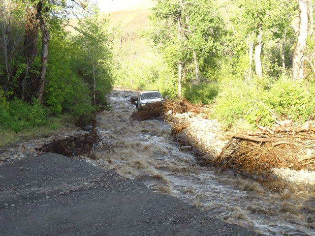
Affects of Flood: May, 2011
How much damage can a few inches of rain do? Want your students to see first hand the power of flood waters and the dynamic of water “floating rocks”?

On May 13, 14 and 15, 2011, about 3″ of rain fell on the Colockum watershed. Combined with the melting snow pack that still existed higher up, the two forks of the Colockum creek converged to became a raging river that did considerable damage to the area (See photo 1). Click here for a Wenatchee World article on the flooding. For the CNRC, it washed out portions of the area in front of the machine shed, deposited nearly 6″ of mud inside the old log cabin and worst of all, washed out about 60% of the road that provides entrance to the unit. Photo 2
In July, 2012, Chelan County Public Works completed work on a new entrance to the CNRC. They created a new entrance to Ingersoll Rd about 1000 feet east of the old beginning of the road. New sign show the way to Ingersol Rd and the Colockum Natural Resource Center.